X-Coastal
Usually those of us who wanted to try our hand at getting some distance up in our paragliders headed inland and thermal flying. But with many of these sites requiring us to travel and with covid restrictions, interest has grown in seeing just how far we can push up and down the coast from our regular flying sites. This sort of flying has been nicknamed X-Coastal and interest in it has been growing fast.
On the Central Coast we have a number of sites where crossing headlands is possible to both the North and South.
This is not intended to be a definitive how to, more of a guide from several of the club pilots who love this style of flying.
It can be challenging, you may be crossing water, jumping headlands, flying close to terrain and landing in unfamiliar and small LZ’s
Here is our guide to two of our sites.
X-Coastal Heading South

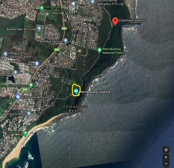
Launching from Crackneck or Foresters Beach depending on the conditions of the day. Travelling south to Wamberal Beach and on to Terrigal.
- Best wind direction E to NE
- Humidity low to medium
- Minimum Height to leave Cromarty lookout at Forrester’s beach >300 metres ASL
Recommended to have a EN B Glider or above.
Two common approaches:
The first is to follow the terrain south over at the back of the beach line and cross over the headland to spoon bay tracking toward Wamberal.
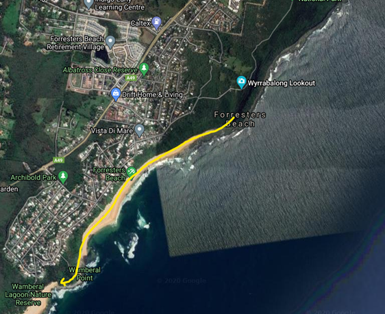
The second is to head over the ocean tracking 10 degrees (slightly)to the East of the Headland to Spoon Bay. When around 200 metres from the headland alter course to track over the headland towards Wamberal surf club.

There are small areas of lift at the back of the beach.
Hazards to be aware of
Areas or rotor on the downwind side of the headlands. If traversing low over the headland.
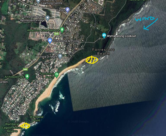
Wamberal lagoon and Terrigal Lagoon:

- Houses, balconies, trees, fences, people, kites and flag poles
- Patrolled areas on both Wamberal and Terrigal beaches
Consider aborting if:
- Lower that 150m ASL
- You feel air turbulence caused by rotor
- Your glide angle means you will be low over a headland or water
- You will put yourself out of range of an easy glide to a safe landing area
- The google earth pic below shows the key locations to be aware of and the routes commonly taken.
Landing areas are any of the Beach area outside the patrolled areas.
X-Coastal Heading North
Crackneck and Foresters Beach travelling North to Shelly Beach and further Nth
- Best wind direction SE from Forries SE to ENE from Crackneck for skilled pilots
- Humidity low to medium
- Minimum Height to leave Crackneck Lookout >200 metres ASL
- EN B Glider or above
Two common approaches:
The first is to leave the lookout and track toward a point just east Bateau Bay northern headland flying over Bateau Bay
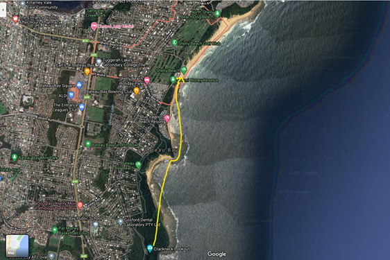
The second is to follow the terrain around the headland and toward Bateau Bay beach until about half way to the beach then track over the bay toward the easterly edge of Bateau Bay northern headland. This route is often used in Easterly and ENE directions.

Nth of that headland there are areas of lift on the headland, tree line nth of Blue Lagoon Caravan Park and toward Shelly Beach Surf Club
Hazards to be aware of:
- Areas or rotor on the downwind side of the headlands. If traversing low over the headland
- Bateau Bay when crossing over the water
- When nearing the Surf Club there is a flag pole near the SE cnr of the building, There is a power pole near the NE cnr or the club
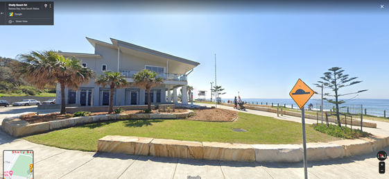
There is a power line running from the power lines at the rear of carpark to a pole on the SE cnr of the toilet block.

- The Surf lifesaving tower on the beach and the patrolled area of the beach
- Occasional Kite flying on the beach areas
- Seats in the grass area nth of the Surf club

Consider aborting if:
- Lower that 100 metres approaching the northern Headland at Bateau Bay
- You are seeing less terrain visible past the headland at Bateau Bay while tracking across the bay
- You feel air turbulence caused by rotor
- Your glide angle means you will be low over a headland or water
- You will put yourself out of range of an easy glide to a safe landing area
Landing Areas
Any Beach area outside of the patrolled areas be aware that the beach area may be narrow in spots and landings may be crosswind.
There are smaller landing zones just nth of Blue Bay Caravan Park and South of Shelly Beach but these are not large areas and only recommended for pilots skilled in tight landing areas.
The landing zone adjacent to the Northern carpark at the Surf Club bears special mention because of the multiple hazards mentioned above. Approach from the eastern side of the toilet block unless you are certain you have sufficient height to avoid the power line above the toilet block and be very careful of members of the public, dogs and children.
Please land on the beach unless you have good landing skills and avoid it altogether if there is a surf carnival on.